The sandakphu trekking is one of the most fulfilling Himalayan ridge walks, which views four highest mountains in the world, the Everest, Lhotse, Makalu, and Kanchenjunga. To the United States based trekkers, who are unfamiliar with the Himalayan surface, it is vital to know the day to day route, elevation gain, nature of trail, and weather. The trail is moderate, not high-altitude climbs but it still needs the knowledge of the changes in altitude, training of endurance, and pacing.
These informational guidelines offer a practical account of the entire route, the altitude gains, the nature of terrain and safety precautions of the route to guide first time trekkers to prepare in a responsible manner.
Itinerary of Sandakphu Trekking
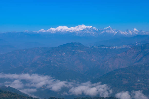
The sandakphu trekking route is along the Singalila Ridge in the India Nepal border. It is characterised with forest areas, open fields, steep climbs, rocky trails, and winding ridges. The peak, Sandakphu, is 11,930 ft, and has a complete 180-degree Himalayan view.
Key Highlights of the Route
• Dense rhododendron forests
• Himalayan villages Trafficking Himalayan villages include Chitrey, Tumling, and Kalipokhri.
• Ridge walks with dramatic mountain walks.
• Vantage points of sunrise and sunset.
Table 1: Overview Core Route and Altitude
| Category | Details |
| Maximum Altitude | ~11,930 ft |
| Trek Distance | 45–65 miles based on different itineraries |
| Ideal Duration | 6–7 days |
| Difficulty Level | Moderate |
| Best Seasons | April–June, October–December |
Day-by-Day Route Breakdown
Day 1 – Day of arrival in Manebhanjan (6,400 ft)
The sandakphu trekking begins at Manebhanjan. Trekkers normally arrive here by Bagdogra Airport or Darjeeling.
What to Expect
• Permit registration
• Gear check and final packing
• Hostel accommodation in homestay or lodge
• Emergency optional land Rover hire
Day 2 – Manebhanjan → Tumling (9,600 ft)
Distance: ~7 miles
Time: 6–7 hours
Route Conditions
Up the steep forest slopes, over cobblestones, and great elevation gain in the first several hours.
Highlights
• Crossing into Nepal (first time)
• View of rolling hills
• Stay at tea house
Day 3 – Tumling → Kalipokhri (10,400 ft)
Distance: ~8 miles
Time: 6 hours
Route Conditions
Cedar lanes bordered with rhododendrons, magnolias and bamboo, paving of stone.
Highlights
• Sleeping Buddha formation view
• Sacred Kalipokhri Lake
• Tea house warm hospitality
Day 4 – Kalipokhri → Sandakphu (11,930 ft)
Distance: ~4–5 miles
Time: 3–4 hours
Route Conditions
Narrow and sharp path, bare ridges, icy breezes.
Highlights
• Everest, Lhotse, Makalu, Kanchenjunga 180-degree view
• Spectacular sunrise/sunset
• Coldest night of the trek
Day 5 – Sandakphu → Sabargram/Molley (11,000–11,200 ft)
Distance: ~9 miles
Time: 6–7 hours
Route Conditions
Ridge walk all along with snow wall in view.
Highlights
• Photogenic landscapes
• Wide, stable paths
• High-altitude meadows
Day 6 – Sabargram → Gurdum (7,800 ft)
Distance: ~10 miles
Time: 6–7 hours
Route Conditions
Acute down through woody gully.
Highlights
• Dense pine and oak forest
• Warmer temperatures
• Village homestays
Day 7 – Gurdum → Srikhola → Manebhanjan
Distance: ~6 miles
Time: 3–4 hours
Route Conditions
Little forest road then a roadway breakout at Srikhola.
Table 2: Breakdown of the Altitude and Distance
| Day | Location | Altitude | Distance |
| 1 | Manebhanjan | 6,400 ft | — |
| 2 | Tumling | 9,600 ft | ~7 miles |
| 3 | Kalipokhri | 10,400 ft | ~8 miles |
| 4 | Sandakphu | 11,930 ft | ~4–5 miles |
| 5 | Sabargram/Molley | ~11,000 ft | ~9 miles |
| 6 | Gurdum | 7,800 ft | ~10 miles |
| 7 | Srikhola | 6,000 ft | ~6 miles |
Sandakphu Trekking Guide: Weather and Visibility
Temperature Pattern
• Spring: cool mornings, mild days
• Fall: clear with freezing nights
• Winter: Harsh winds, snow
• Monsoon: Warm, humid, unsafe
Wind Pattern
Phalut and Sandakphu ridges experience heavy winds particularly during late autumn and winter.
Visibility Pattern
The optimum views of the mountains are in:
• April–May
• October–November
• Early morning sunrise hours
Accommodation in the Trek
Tea House Features
• Basic bedding
• Simple vegetarian food
• Shared washrooms
• Limited heating
Charging and Connectivity
• Solar charging options
• Poor or no road farther inland than Tumling
Fitness Conditions of Sandakphu Trekking
Physical Expectations
• Ability to walk 7–10 miles daily
• Comfort with steep hills
• Varying path joints that are stable
• Good cardio endurance
Pre-Trek Recommended Training
• Hill climbs
• Daily long walks
• Strength exercises (lungees, squats, planks)
• Light running or cycling
Table 3: Rating of Fitness Difficulty
| Factor | Level |
| Altitude | Moderate |
| Daily Distance | Medium–High |
| Temperature Variation | High |
| Terrain Type | Forest, ridge, steep ascent |
| Overall Challenge | Moderately strenuous |
Essential Packing List
Clothing
• Thermal layers
• Down jacket
• Waterproof outer layer
• Warm gloves and hat
• High-ankle boots
Gear
• Trekking poles
• Headlamp
• Water purification method
• Power bank
• Sunglasses & sunscreen
Food & Hydration
• Energy bars
• Electrolytes
• Nuts and light snacks
High-Flying Awareness and Safety
Symptoms to Watch For
• Dizziness
• Fatigue
• Headache
• Loss of appetite
Prevention
• Slow and steady walking
• Drinking water frequently
• Rest on steep days
• Avoid alcohol
Quotes
Mountains are more rewarding to the patient than the quick.
Those who walk early These are clear skies.
Preparation and not speed is the honour of Altitude.
FAQs
What is the time taken in sandakphu trekking?
Approximately 6–7 days based on the route and speed.
To what maximum height is this raised?
Some 11,930 feet in Sandakphu.
Is the sandakphu trekking good back then?
Yea, in due preparation and condition.
What is the most appropriate time of the year to take this trek?
Spring (April–June). Fall (October–December).
Do trekkers need a guide?
Not compulsory, but helpful in navigation and safety.
Conclusion
The route that is provided by sandakphu trekking is one of the most breathtaking walks in the Himalayas. The trail is a mixture of moderate challenge, gradual uphill, and memorable sceneries of four of the highest mountains in the world. The United States of America can safely enjoy this classic high altitude trip with the right preparation, which includes physical training, awareness of weather, proper equipment and a realistic day to day plan. The right planning will guarantee the comfort, safety and the chance to view world-class Himalayan landscape through one of the very best natural perspectives anywhere on the globe.