The sandakphu trek is among the most beautiful highways path in the Eastern Himalayas that has panoramic views of four tallest mountains in the world: Everest, Lhotse, Makalu, and Kanchenjunga. The route has the advantage of being a moderate level of challenge, safety, and a memorable landscape to first-time high-altitude trekkers in the United States. The trek is rated as easily accessible, though it still requires adequate planning, slow hiking, and reflections of the change in altitude.
The informational guide is a day-to-day itinerary with details of the day-to-day events, trail conditions, weather patterns, places to stay at night and safety measures that would help new trekkers plan well in advance.
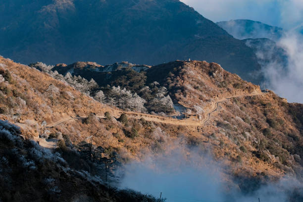
Learning the Sandakphu Trek Route
The sandakphu trek is located on the border between India and Nepal where it passes through forests, ridges, small villages of the Himalayas, and open fields. The peak of the mountain, Sandakphu is about 11,930 feet. Adenosine Trekking requires a gradual climbing profile and thus, this trail is appropriate to novices provided they train the body and get used to the height.
Table 1: Core Trek Overview
| Category | Details |
| Maximum Altitude | ~11,930 ft |
| Total Distance | 50 miles (average) to 46 miles (average) |
| Ideal Duration | 6–7 days |
| Difficulty Level | Moderate |
| Best Seasons | April–June, Oct–Dec |
Sandakphu Trek Day-by-Day Itinerary
Day 1 – Arrival in Manebhanjan (6,400 ft)
Trekkers normally reach Manebhanjan through Siliguri or Darjeeling. This small town located on the border is the starting point of the trek.
What to Expect
• Permit check-in
• Final gear inspection
• Staying at a homestay or a lodge
Manebhanjan can also rent 4×4 Land Rover in case of descent emergencies or other forms of travel.
Day 2 – Manebhanjan to Tumling (9,600 ft)
Distance: ~7 miles
Time: 6–7 hours
Route Conditions
The trail starts with a steep path with heavy forest cover. At the beginning of the path, one can see the legendary Monastery of Chitrey.
Highlights
• Entering Nepal on the first border
• Scenes of the low lying Himalayan hills
• Overnight in a tea house
Day 3 – Tumling to Kalipokhri (10,400 ft)
Distance: ~8 miles
Time: 6 hours
Route Conditions
The road passes through dense rhododendron, magnolia and bamboo forest. Sections of the trail are paved with stones.
Highlights
• A good sight of the formation of the Sleeping Buddha
• Lake of black-water (which is considered holy) of Kalipokhri
• Hospitality of tea houses that is warmer
Day 4 – Kalipokhri to Sandakphu (11,930 ft)
Distance: ~4–5 miles
Time: 3–4 hours
Route Conditions
This is the steepest day, though short, open and windy ridges.
Highlights
• Sunrise/sunset at Sandakphu
• View of Everest, Lhotse, Makalu and Kanchenjunga at 180 degrees angle
• Coldest night of the trek
It is not so much about speed as much as it is patience with the altitude in order to reach Sandakphu.
Day 5 – Sandakphu to Sabargram/Molley (11,000–11,200 ft)
Distance: ~9 miles
Time: 6–7 hours
Route Conditions
The path cuts across lengthy open ridges and there is a constant sight of the snowy Himalayan wall.
Highlights
• Spectacular ridge walk
• The perfect light to take photographs
• Stable trail surface
Day 6 – Sabargram to Gurdum (7,800 ft)
Distance: ~10 miles
Time: 6–7 hours
Route Conditions
This day is an extensive drop through woods and fields.
Highlights
• Dense Himalayan forest
• Warmer climate
• Local homestay experience
Day 7 – Gurdum to Srikhola and back to Manebhanjan
Distance: ~6 miles
Time: 3–4 hours
Route Conditions
A soft forest path will take one to Srikhola and the trek is over. Trekkers make a retreat to Manebhanjan or Darjeeling.
Table 2: Breakdown of Altitude and Distance
| Day | Location | Altitude | Distance |
| 1 | Manebhanjan | 6,400 ft | — |
| 2 | Tumling | 9,600 ft | ~7 miles |
| 3 | Kalipokhri | 10,400 ft | ~8 miles |
| 4 | Sandakphu | 11,930 ft | ~4–5 miles |
| 5 | Sabargram/Molley | ~11,000 ft | ~9 miles |
| 6 | Gurdum | 7,800 ft | ~10 miles |
| 7 | Srikhola | 6,000 ft | ~6 miles |
Weather Expectations
Temperature Pattern
• Spring: Chilly mornings, cool afternoons
• Fall: Clear skies, freezing nights
• Winter: Bitter wind, snow drifts
• Monsoon: Warm but unsafe
Wind Pattern
Sandakphu is also reputed to have strong winds mostly during fall and winter. People can experience temperatures that are lower than the actual temperature.
Visibility Pattern
It is mostly seen in clear views in:
• April and May
• October and November
The best times to have peak views are early in the morning at sunrise.
Accommodation Style
The sandakphu trek route is overrun by tea houses and homestays.
Tea House Features
• Basic bedding
• Simple vegetarian meals
• Shared washrooms
• Limited heating
Electricity and Charging
• Solar powered charging in majority of the villages
• Unable or poor cellular networks past Tumling
Fitness Conditioning of First-Time Trekkers
Physical Expectations
• Ability to walk 7–10 miles per day
• Ability to deal with steep rises
• Comfort with cold weather
Pre-Trek Recommended Training
• Hill climbing practice
• Daily walking routine
• Squats, lunges, planks
• Light jogging or cycling
Mental Preparedness
The trekking in the high altitudes requires stability rather than power.
Going at the right pace, being patient and staying hydrated are more influential than speed.
Table 3: Factors of Rating of Difficulty
| Factor | Level |
| Altitude | Moderate |
| Daily Distance | Medium–High |
| Temperature Variation | High |
| Terrain Type | Forest, ridge, steep ascent |
| Overall Challenge | Leisure and challenging |
Essential Packing List
Clothing
• Thermal inner layers
• Down jacket
• Waterproof jacket & pants
• Woolen cap & gloves
• High-ankle trekking boots
Gear
• Trekking poles
• Headlamp
• Water purification tablets
• Power bank
• Sunglasses and sunscreen
Food & Hydration
• Energy bars
• Electrolyte packets
• Easy-to-digest snacks
Safety and Altitude Notes
Symptoms to Watch For
• Headache
• Dizziness
• Loss of appetite
• Fatigue
Even though the sandakphu trek is moderate in terms of altitude in comparison with most of the Himalaya trails, novices must exercise caution.
Prevention
• Walk slowly
• Hydrate frequently
• Rest on steep days
• Do not consume alcohol on the trek
Quotes for Inspiration
The beauty of a mountain cannot be viewed by anyone who does not climb it slowly.
Preparation is a reward and hurry a punishment to the altitude.
When the trekker is prepared, then the Himalayas appear.
FAQs
Can the sandakphu trek be used by beginners?
Yes. It is said to be among the novice friendly high altitude treks.
So what is the optimal season of the sandakphu trek?
April–June and October–December.
What is the difficulty of sandakphu trek?
Middle level with bearable heights and distinct paths.
Would I be able to do sandakphu trek without a guide?
Yes, however the first-timers will have the advantage of having local guides to lead them about and also to be on the safe side.
What is the elevation of sandakphu trek?
Approximately 11,930 feet.
Conclusion
Sandakphu trek is a good introduction to high altitude trekking by the United States travelers. It has an intermediate level of difficulty, breathtaking ridgeline trails and unmatched views of the highest peaks in the world and it has the best combination of adventure and safety. With the correct itinerary, physical training, and knowledge of weather and terrain conditions, it is known that first-time trekkers will be able to enjoy this Himalayan trail successfully and with ease.